INTRODUCTION
Surveying and the Law cannot be separated. An owners title to land along
a river or lake is dependent upon the law. These same owners have rights
which are also defined by the law-- in water boundary work we use the term
riparian rights. There are two kinds of riparian rights: The rights
to the water itself and the rights incident to the land. Those incident
rights may include ownership of, or use of, the bed of the water body or
the ownership of land exposed by the action of the flowing water. The boundaries
of riparian land are determined according to the law, including statute
law, case law and, sometimes, administrative law.
 The
rectangular system of surveying (also called public land surveys) is considered
brieflymainly as to its application to riparian property. Meander lines
and meandering is discussed and illustrated.
The
rectangular system of surveying (also called public land surveys) is considered
brieflymainly as to its application to riparian property. Meander lines
and meandering is discussed and illustrated.
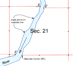
Meander Corner monuments,
abbreviated
MCs, were set at each
point where a
section line intersected
a meanderable
river or lake.
Because case law is the basis for surveys of water boundaries the following
law cases are analyzed and illustrated:
First National Bank of Decatur v. United States
United States v. Cowlishaw et al.
Whitaker v. McBride
Weaver v. Knudson
Of particular interest in the illustration of these cases is that the
published cases do not ordinarily include a map or even a sketch in the
way of illustration. The reader must therefore, try to visualize the situation
on the ground from the judges summary of the facts. One of the main advantages
of study using River & Lake Boundaries is that old maps have been reproduced
so as to show the physical relationships of the land boundaries to the
water. A proper understanding of the cases depends on a correct understanding
of the facts on the ground.